The Senni Valley, Brecon Beacons – an ‘ancient’ landscape
The Senni Valley is located in the heart of the Brecon Beacons National Park.
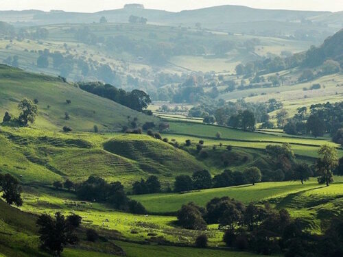
The distant photograph shows the difference in the landscape between the open moorland on the higher hills, the wooded steeper slopes and the smaller, sheltered fields in the valley bottom. Originally formed by a glacier, this U-shaped valley shows many of the characteristics of ‘ancient’ or ‘wooded’ landscapes found in the west and north of Britain. The fields are small with irregular shapes formed piecemeal in Prehistoric or Roman times as the wooded land was cleared for farming, although, as the photograph shows, much of the woodland survives. The roads are similarly irregular in shape and link a settlement pattern of isolated and dispersed farms. The largest settlement in this valley is Heol Senni consisting of just a few houses. This landscape has survived relatively unchanged and remained unaffected by the enclosure of fields and nucleation of villages that occurred further to the south and west in Britain. The once glaciated valley has no major road and its relative isolation has helped to maintain its character through to the present day. The photograph from the valley floor shows even more clearly the irregular shape of the small fields and the amount of woodland that survives. Many houses in this area are located on the slopes of the valley sides, leaving the flat valley floor for farming.
Address: Hoel Senni, Brecon, LD3 8SU